Lanes and Lane Counts Home Page
2023 LiDAR
Lanes
Each feature represents the extent of a lane on the State Highway System or a related ramp. These linear features generally follow the center of each lane. The key attribute for each feature is the type of lane (e.g, "thru", "right turn lane").
Notes:
- Where one lane expands into two lanes (or vice versa), the geometry of the Lane feature will follow the middle of the lane (between the paint stripes) at the end of the segment where there are fewer lanes but will be placed between the two lanes (ON the paint stripe) at the end of the segment where there are more lanes. This can result in "breaks" in the linear features even where one of the lanes continues seamlessly.
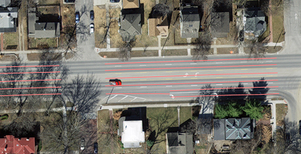
- The Lane Counts features are a companion to these features intended to provided a total count of lanes by Type for any given stretch of road.
- Please note that there are some Lane features for peripheral routes that intersect the State Highway System at grade but they are sporadic/inconsistent. There may also be "missing" lane features on these connnecting routes since the extraction requires lane striping and many of these side roads don't have them. The dashboard includes only Lane features on the State Highway System but all extracted features are included in other posted versions of the data.
Lane Counts
Each feature represents all lanes of traffic flowing in the same direction along a roadway, with seamless breaks between features where the number of lanes changes. They are intended as a companion to the Lane features and essentially sum the number of lanes by type for any given section of road.
The bulk of the features are for the State Highway System and related ramps though portions of other, connecting roads are included across the state. These peripheral features have been removed from the dashboard, though other posted versions of the data include some features related to intersections of roads off the State Highway System.
The features follow the geometry of the linear referencing system data KDOT provided to Cyclomedia for the project. For one-way roads and ramps, only a single feature is used. For two-way roads on a single carriageway, two features will be used (one for the "inventory" direction and the other for the "non-inventory" direction) but they will spatially overlap/duplicate each other. For two-way roads that each follow separate carriageways (e.g., divided highways), one feature will be provided per carriageway.
2021 LiDAR
Not Collected in 2021
KDOT makes no warranties, guarantees, or representations for accuracy of this information or any materials that are downloaded and assumes no liability for errors or omissions. In addition, KDOT makes no warranties, guarantees, or representations for the private or public use of any information or materials found on this site, the use of any information or data is at the user’s own risk.
